

Understand the natural and human history that shapes Santa Cruz’s north coast.
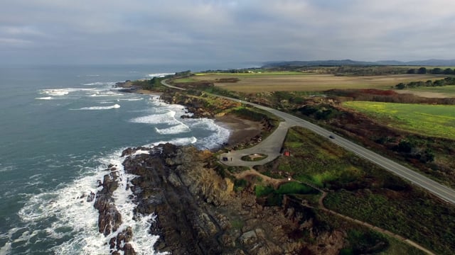
With each mile on this coastal driving tour, the road hugs along steep cliffs, passes breathtaking beach views and twists through rolling hills of coastal sage scrub. The eight stops span roughly 30 miles that will take you through times of railroad barons, introduce the “Cement King”, and explain how local rocks control the appearance of the coast.

We highlight a few stops below but the main content can be found in the mobile app or read in blog form at the bottom of this page.
At Long Marine Lab you’ll see several whale skeletons, including Ms. Blue the world’s largest blue whale skeleton.

Stop at Bonny Doon Beach and learn why you cannot see the ocean as much as you should along this stretch of highway.

Be sure and hunt for opal and jasper treasures at Pebble Beach (Bean Hollow State Beach North) and find out why you will feel so “uplifted.”


-

The California buckeye (Aesculus californica) is the smart spring bride of the dry canyons of the central coast ranges and Sierra Nevada mountains to abou ...
-

Lots of great things happen at Long Marine Laboratory, including marine research, marine education, and lagoon and bluff habitat restoration. The lab sits ...
-

California's Bonny Doon Beach is home to wide-open sands, a creek that runs through it, and even a clothing-optional section to the right of the chunk of ...
-

The railroad pictured here was not part of the north-south Southern Pacific or Ocean Shore Electric Railway that ran along the coast from Santa Cruz. It r ...
-

There are many ways to show support for your country’s troops, but would you ever think of making the world’s largest cheese to raise money for hungry sol ...
-

The Santa Cruz Mudstone is the rock type that shapes the landscape characteristics of the northern Santa Cruz coast from the north county line through to ...
-

Wilder Ranch has just about everything to provide the quintessential California coast experience. It is a large (7,000-acre) park with trails for hikers, ...
-
Many thanks to Barry Blanchard for permission to use this video. Women in bloomers and children in search of treasure once flocked to Pebble Beach to spen ...
-

Along Highway 1, sandwiched between the elephant seals at Año Nuevo State Park and the colorful kite surfers at Waddell Beach, is a 1.4-mile stretch of co ...
-

If you're a local you may have wondered why you can't see the ocean very often when you drive between Santa Cruz and Davenport. It's because every creek a ...
-

Settlement in the area of today's Davenport got its start in 1868 when Captain John Davenport, a sea-based whaler by trade, built a 450 foot wharf off wha ...
-

If you look in the northern most cove at Bonny Doon Beach, (yes, it's the clothing-optional section), you will see a tall skinny dike of sandstone that cu ...


